


On the Basilicata side of Pollino National Park, limestone peaks, ancient pines and quiet Albanian-heritage villages create one of southern Italy’s most rewarding hiking areas. Less crowded than the better-known Dolomites or Gran Paradiso, this corner of the southern Apennines offers serious mountain routes, gentle river walks, and easy access to rafting on the Lao River just across the border in Calabria. This guide focuses strictly on the Lucanian (Basilicata) side of the park, helping you choose the right base village, understand official trail grades, and combine independent hiking with reputable local operators.
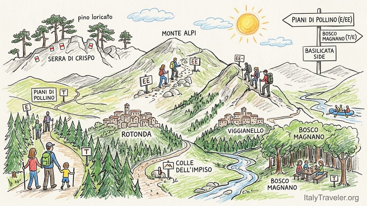
Understanding the Basilicata Side of Pollino
Pollino National Park stretches across Basilicata and Calabria, but the experience is very different on each side. The Lucanian section, around Rotonda, Viggianello, San Severino Lucano, Terranova di Pollino, San Costantino Albanese, Castelluccio Superiore and Latronico, is quieter and feels more rural, with small stone villages overlooking beech forests, river valleys and high pastures. The highest peaks of the Pollino group sit largely on the regional border, but access from Basilicata is via classic trailheads such as Colle dell’Impiso and the Piani di Pollino.
Officially, around 88,000 hectares of the park fall within Basilicata, out of a total of about 192,000 hectares. This includes the Mercure valley near Rotonda and Viggianello, the Valle del Sarmento around Terranova di Pollino and San Costantino Albanese, and the forested slopes around Latronico and Castelluccio Superiore. These areas share access to the same high limestone ridges, but road connections between valleys are slow, so where you base yourself matters for how much walking you can realistically fit into a short trip.
Pollino is best known for its ancient Bosnian pines (pino loricato) that cling to high ridges like Serra di Crispo and Serra del Prete, and for its network of long-distance ridgeline routes that can feel surprisingly wild compared to many Alpine destinations. At the same time, family-friendly river walks such as Bosco Magnano near San Severino Lucano offer shaded paths beside clear streams. This contrast makes the Basilicata side attractive to mixed groups, as long as everyone understands what the various official trail grades really involve.
Throughout this article, references to rafting on the Lao River and some high ridges accessible from Colle dell’Impiso touch on routes that overlap administratively with Calabria, but accommodation and the main access roads described here are all on the Basilicata side. When booking tours, transport and guiding, always check which village is your actual departure point and which side of the regional border an activity is on.
Trail Difficulty: T, E and EE on Pollino
On Pollino, official trails use the standard Italian CAI grading: T for tourist paths, E for hikers, and EE for experienced hikers. On the Lucanian side the park authority lists classic routes such as Latronico – Rifugio Bosco Favino – Monte Alpi as EE, while itineraries like Viggianello – Rifugio Fasanello or Castelluccio Superiore – Monte La Spina are graded E. This classification already takes into account not only steepness and length but also potential exposure, terrain underfoot and how easy it is to follow waymarks.
Broadly, T routes are wide, well-traced tracks on gentle ground with modest ascent, generally up to about 300–400 metres. Bosco Magnano’s main riverside path is a good example, with short, mostly level sections suitable for families who are used to walking at least a couple of hours. E routes involve steeper slopes, narrower paths and longer distances, such as many access paths from Colle dell’Impiso to the high meadows of the Piani di Pollino, where you may cover 600–800 metres of ascent over a full day hike.
EE routes on Pollino, such as Rifugio Bosco Favino to Monte Alpi, demand more fitness and comfort on steep or exposed ground. That particular route climbs roughly 650–730 metres from around 1345 metres at Rifugio Favino to about 1900 metres on the Monte Alpi crest, over approximately 8 kilometres there and back. The upper section traverses a long, airy ridge where the path can be rocky, with sections of scree and short exposed passages, which is why local Alpine clubs list it as E/EE rather than an easy walk.
Because of this, itineraries like Favino – Monte Alpi are not appropriate to sell as casual family walks, even if confident teenagers with some hiking experience might cope well in good conditions. The combination of sustained ascent, lack of shade on the ridge, patchy mobile reception and a long return on tired legs means that inexperienced walkers, young children or anyone with mobility issues are better off on shorter E-grade forest circuits or T-grade river trails. Hiring a guide is sensible whenever you are unsure about navigation or your group’s stamina, particularly on routes classified EE.
Choosing Your Base: Lucanian Villages Compared
Rotonda sits at about 580 metres in the Mercure valley and is often treated as an informal gateway to the park on the Basilicata side. It has a compact historic centre, several small hotels and guesthouses, and easy road access towards Colle dell’Impiso and the Piani di Pollino. For travellers arriving by car from the Tyrrhenian coast or from the A2 motorway, this is usually the fastest base to reach, and it works well for first-time visitors who want a mix of village atmosphere and access to the main high mountain trailheads.
Viggianello, a short drive from Rotonda, has a similarly atmospheric old nucleus and overlooks the upper stretches of the Mercure River. It is slightly quieter and more dispersed, with agriturismi and B&Bs scattered between the main village and hamlets like Pedali. Viggianello is a logical base if you are attracted by forest walks, moderate E-grade itineraries and the cultural link with the sanctuary of Madonna di Pollino, which can be reached on foot along sections of the Cammino Basiliano or via road from San Severino Lucano.
San Severino Lucano and Terranova di Pollino sit deeper inside the park and work well for those prioritising access to Bosco Magnano, Madonna di Pollino and the eastern ridges such as Serra di Crispo and Serra delle Ciavole. San Severino is closer to Bosco Magnano and the sanctuary, while Terranova commands views over the Valle del Sarmento and gives quicker access to the high plateau trailheads leading towards Serra del Prete and the inner Pollino group. Accommodation here is more limited in number but often closer to the main dirt roads used by local guides.
San Costantino Albanese, Castelluccio Superiore and Latronico all make sense for more exploratory trips or for repeat visitors. San Costantino Albanese is an Arbëreshë (Albanian-heritage) village above the Sarmento valley, known for its cultural festivals and for adventure activities such as zip-lines in the wider area. Castelluccio Superiore offers quick access to Monte La Spina and wooded ridges on the southern edge of the park. Latronico, slightly outside the core zone, combines access to Monte Alpi via Rifugio Favino with spa facilities in town, which can be appealing for mixed-interest groups where not everyone will hike every day.
Key Hiking Areas: From Bosco Magnano to Monte Alpi
Bosco Magnano, reached from the San Severino Lucano area and often associated administratively with Latronico, is one of the easiest Pollino landscapes to enjoy without serious mountain experience. The forest stretches along the Peschiera stream, with shaded paths beneath oaks, hornbeams and beech trees. Signposted riverside trails and picnic areas allow for short T-grade walks suitable for families, with minimal ascent and regular access to water from the stream and fountains near recreation zones. In early summer weekends it can be busy; weekdays and autumn see far fewer people.
The sanctuary of Madonna di Pollino stands on a rocky spur at around 1,530 metres, above the Valle del Frido. Access by car from San Severino Lucano or Viggianello is straightforward along paved mountain roads, but walking routes from the valleys below create more satisfying E-grade outings. Sections of the Cammino Basiliano from Viggianello to the sanctuary involve long, steady climbs on mule tracks and quiet lanes. There are no reliable water sources on the upper sections, so walkers should start with sufficient water for the day, especially in late spring and summer when south-facing slopes heat up quickly.
Serra di Crispo, one of the emblematic ridges of Pollino, is best accessed from the eastern side of the park via trailheads reached from Terranova di Pollino or San Costantino Albanese. Routes from Colle di Gaudolino or Piano Toscano, listed as EE by park and Alpine Club sources, involve significant ascent and traverse high, sometimes pathless slopes scattered with the twisted forms of Bosnian pine. These routes are serious mountain days, typically with 900 metres or more of climbing, no potable water once you leave the beech forests, and only intermittent paint marks on rocks to guide the way. On clear days, however, they offer far-reaching views over both Basilicata and Calabria.
Monte Alpi, on the other hand, sits slightly detached from the main Pollino chain, above Latronico. The usual ascent from Rifugio Bosco Favino begins around 1,340 metres in a beech forest and climbs to roughly 1,900 metres along the crest of Pizzo Falcone and nearby summits. The first section follows forest tracks and is generally well marked with red and white blazes and signposts. Higher up, the ridge narrows and footing can be uneven, which is why official documents and Alpine club itineraries classify the route as E/EE rather than simple E. There is usually water at the start near the picnic area, but hikers should not rely on finding water higher up, especially from late summer onwards.
Colle dell’Impiso, Piani di Pollino and Viggianello’s Forest Walks
Colle dell’Impiso, reached by a mountain road from Rotonda and Viggianello, is the classic starting point for many of the highest routes on Pollino. From around 1,570 metres you can follow E-grade paths across grassy slopes and through mixed woodland to reach the Piani di Pollino, a high karst plateau ringed by ridges such as Serra del Prete and Serra delle Ciavole. Typical day hikes from the pass involve 600 to 900 metres of ascent and can last six to eight hours, with long stretches above the treeline. In good weather trails are reasonably clear, but early-season snow patches and fog can make navigation tricky.
The Piani di Pollino themselves offer intermediate hikers the chance to experience the park’s famous open landscapes without committing to full EE-grade ridge traverses. Circuits that skirt the base of the main ridges, keeping to the meadows, are generally classed as E and can be tailored by turning back early or extending towards higher cols. There are no reliable springs on the plateau in late summer and early autumn, so you must carry all the water you need for the day. Spring and early summer often bring wet ground underfoot as snowmelt drains into the sinkholes that punctuate the meadows.
Closer to Viggianello, several forest itineraries offer lower-elevation alternatives for days with poor weather on the high ridges or for less experienced walkers. These E-grade routes tend to weave through beech and mixed woodland above the Mercure valley, with moderate ascent and well-trodden paths used by local residents. Waymarking can be patchy on lesser-known circuits, so a recent printed map or GPS track from a local guide office in Rotonda or Viggianello is worth having. These walks usually offer occasional springs and small streams, but in late summer some may run dry, so you should still start out with enough water for the day.
For visitors staying in Castelluccio Superiore, nearby Monte La Spina and local ridges provide additional E-grade options at similar elevations, again mostly within forest or on open pastures rather than on fully exposed limestone crests. These routes see fewer outsiders, so although they are marked, vegetation can encroach on the path in late spring and early summer. Sturdy long trousers and a willingness to backtrack if you lose the way are advisable if you set out alone on these quieter trails.
Local Guides, Outdoor Operators and Lao River Rafting
On the Basilicata side of Pollino there is an active network of guides, small agencies and outdoor associations based between Rotonda, Viggianello, Terranova di Pollino and San Severino Lucano. Some, like region-wide adventure outfits headquartered in Basilicata, advertise trekking, e-bike and rafting combinations that include Pollino alongside other areas of the region. Their Pollino programmes typically feature guided E or EE hikes from Colle dell’Impiso or Monte Alpi, sometimes paired with a rafting day on the Lao River in neighbouring Calabria.
It is important to understand that the most famous rafting runs are on the Lao River as it flows through Calabria, with the standard departure villages of Laino Borgo and Laino Castello. Several long-established rafting centres operate there, offering half-day and full-day descents through gorges that cut below the Pollino ridges. These operators often work with accommodation providers in Basilicata, arranging transfers so that guests staying in Rotonda or Viggianello can add rafting to a hiking holiday. When booking from the Basilicata side, check whether your package includes transport to and from Laino Borgo, and confirm where you will meet your guides.
Mountain biking, e-bike tours and horse riding are also well represented around the Lucanian villages. Local guides based near Viggianello and Terranova di Pollino advertise guided e-bike loops through the Valle del Mercure, dirt road ascents towards the Piani di Pollino, and gravel itineraries linking hamlets in the Valle del Sarmento. Riding stables and agriturismi offer half-day horseback excursions on forest tracks above Viggianello or San Severino Lucano, usually aimed at beginners and families, with walking pace rides and helmets provided. In all cases, confirm that the guide or instructor is appropriately certified and that equipment is in good condition.
Prices for guided activities vary by season and group size, but as a broad indication, a full-day guided hike with a qualified local mountain guide often falls into the range of what you would expect in other Italian national parks for similar services. Rafting on the Lao River, including equipment such as wetsuits, lifejackets and helmets, is typically charged per person, with discounts for families and larger groups. Since local inflation and operating costs change from year to year, it is worth contacting operators directly in the months before your trip for updated rates, and checking whether park entrance, transfers and insurance are included.
Independent Hiking vs Guided Packages
Hiking independently on the Basilicata side of Pollino is entirely feasible for those with previous mountain experience, solid navigation skills and the right equipment. Main trailheads like Colle dell’Impiso, Rifugio Bosco Favino and the access roads to Bosco Magnano are clearly signposted from nearby villages, and popular E and EE routes are usually marked with painted red and white stripes on rocks and trees. A detailed printed map of the park and a GPS app with offline maps are strongly recommended, as waymarks may disappear under snow or vegetation.
Going without a guide saves the daily guiding fee and gives you flexibility to change plans according to weather or how you feel. It works best for lower-elevation T and E routes, such as riverside walks in Bosco Magnano, forest loops above Viggianello and approaches to the Piani di Pollino that do not venture onto the highest ridges. Independent hikers should still carry essentials: sturdy hiking boots, waterproofs, extra layers, sun protection, at least 1.5 to 2 litres of water per person for moderate day walks, snacks, a basic first-aid kit and a headtorch in case you are delayed.
Guided packages, whether for a single day or as a multi-day itinerary, add cost but can significantly increase safety and reduce stress, especially on EE routes and early or late in the season. A local guide who knows the ridges of Serra di Crispo or Monte Alpi can adjust the route to avoid steep snow patches, anticipate afternoon thunderstorms and identify safe bailout options if part of the group is tiring. Many guides also provide educational context on the park’s geology, forests and traditional land use, which greatly enriches the experience.
Equipment provided on guided hikes varies. Some guides supply trekking poles and helmets for sections under cliffs or in minor scree, while on rafting or canyoning days all specialist gear is normally included. When comparing offers, ask in writing what is included in the price, what the minimum and maximum group sizes are, and whether the guide is registered with regional or national mountain guide associations. For families and beginners, particularly those unfamiliar with the T/E/EE grading system, one or two guided days at the start of a trip can be an excellent orientation before exploring easier trails independently.
When to Go, Weather and Safety
The Basilicata side of Pollino has a mountain climate that differs markedly from the coastal lowlands of southern Italy. Snow typically covers the highest ridges from late autumn through early spring, and can linger on north-facing slopes around Colle dell’Impiso and Serra di Crispo well into May. In these months many EE routes are effectively alpine outings, requiring winter equipment and experience that most visitors will not have. For high-level hiking without snow gear, the most reliable months are usually mid-June to late September, although exact conditions vary from year to year.
Summer brings long daylight hours and clear mornings, but temperatures in the valleys can climb sharply in July and August. Starting early is essential for routes like Monte Alpi or full-day circuits on the Piani di Pollino, both to avoid afternoon heat lower down and to reduce exposure to sudden storms building over the peaks. On the ridges, wind can be strong even on otherwise warm days, so an extra layer and light gloves are worth packing. In shoulder seasons like late May or early October you may encounter a mix of spring-like warmth in the forests and near-freezing windchill on exposed summits.
Water availability is a critical safety factor. On riverside T routes like Bosco Magnano there is usually water in the stream, but it is not treated, so visitors who wish to drink it should use filters or purification tablets. On most E and EE routes above the treeline, especially around the Piani di Pollino and Serra di Crispo, there are no reliable springs once you leave the beech forest. Plan to carry all the water you need for the day and factor in extra for hot conditions. Fountains listed on older maps may be dry, damaged or seasonally intermittent.
Phone coverage is patchy away from villages and main roads, and weather forecasts can change quickly. Before setting out, tell your accommodation where you plan to walk and roughly when you expect to return. In case of doubt about snow, storms or your group’s fitness, scale back to a lower E or T route or hire a guide. Do not count on seeing wolves, golden eagles or other elusive wildlife; while they live in the wider Pollino area, sightings are rare and should be treated as a bonus, not an expectation.
Suggested Itineraries: 2, 3 and 5 Days
For a two-day introduction aimed at families or beginners, Rotonda or Viggianello are the strongest bases. A practical plan is to spend the first day on a gentle outing in Bosco Magnano or along one of the forest tracks above Viggianello, keeping to T or easy E terrain with modest ascent and frequent shade. On the second day, join a short guided walk towards the Piani di Pollino from Colle dell’Impiso, turning back before the longest climbs but still getting a sense of the high meadows. Accommodation in these villages often includes small guesthouses with family rooms and the option of half-board, simplifying logistics.
A three-day stay suits hikers with moderate experience who want a mix of independent walking and perhaps a rafting day. One option is to base yourself in Viggianello or Rotonda, devote the first day to a self-guided E-grade hike to the Piani di Pollino, the second day to a Lao River rafting run arranged through a local operator with transfers to Laino Borgo, and the third day to a cultural and landscape walk linking Viggianello with the sanctuary of Madonna di Pollino, either entirely on foot or using a vehicle drop-off to shorten the ascent. This combination offers three distinct environments: high karst meadows, river gorge and devotional landscape.
For experienced hikers with five days and a car, Terranova di Pollino or San Severino Lucano make excellent bases if your priority is serious mountain walking. A sample programme might include an EE-grade ascent to Serra di Crispo or a long ridge traverse above the Valle del Sarmento, a full-day hike from Colle dell’Impiso to the Piani di Pollino and back, a demanding day on Monte Alpi from Rifugio Favino, and two lower-intensity days on forest and valley routes to recover. You could, for example, spend one recovery day on an easy T walk in Bosco Magnano and another exploring short village-to-village paths around San Costantino Albanese.
In each case, the best village base depends on your priorities. Families and first-time visitors who value convenient facilities, shorter drives and access to a range of easy outings will be most comfortable in Rotonda or Viggianello. Those seeking immersion in high mountain landscapes and who do not mind narrower roads and fewer services can favour Terranova di Pollino or San Severino Lucano. Repeat visitors or mixed-interest groups might choose Latronico, combining spa time in town with one or two big days on Monte Alpi and nearby ridges.
The Takeaway
The Basilicata side of Pollino National Park offers far more than a quiet alternative to busier mountain regions further north. From the wooded riverbanks of Bosco Magnano to the pale limestone ridges of Serra di Crispo and Monte Alpi, it combines serious routes for experienced hikers with gentle family-friendly landscapes, all within a compact but varied area. The key to enjoying it is matching your base village and daily plans to your actual fitness, experience and appetite for adventure, rather than to the marketing slogans that sometimes gloss over trail difficulty.
By paying attention to official T, E and EE grades, respecting seasonal realities like snow and summer heat, and being honest about your own abilities, you can tailor a rewarding itinerary whether you have two days or a full week. Independent hikers will appreciate the freedom and sense of discovery on quieter forest paths, while guided days add security and insight on the most challenging ridges or during shoulder seasons. With realistic expectations, flexible planning and a willingness to embrace both the high peaks and the villages below them, Pollino’s Lucanian side reveals itself as one of southern Italy’s most compelling mountain destinations.
FAQ
Q1. Which village is the best base on the Basilicata side of Pollino for a first visit?
Rotonda or Viggianello work best for most first-time visitors, thanks to their mix of accommodation, services and easy access to Colle dell’Impiso and other classic trailheads.
Q2. Is Bosco Magnano suitable for small children and less fit walkers?
Yes, the main riverside paths in Bosco Magnano follow mostly flat ground in the shade of the forest, making them appropriate T-grade walks for families used to short outings.
Q3. Why is the Rifugio Bosco Favino to Monte Alpi route not a casual family hike?
Because it involves around 650 to 700 metres of ascent, sections of steep and exposed ridge, and a long return on uneven terrain, so it is graded E/EE for experienced hikers.
Q4. When is it necessary or sensible to hire a mountain guide on Pollino?
Hiring a guide is advisable for EE routes such as Serra di Crispo or Monte Alpi, in early or late season when snow may be present, or whenever you are unsure about navigation or your group’s fitness.
Q5. Can I do Lao River rafting while staying in a village on the Basilicata side?
Yes, many local operators based in Basilicata arrange rafting on the Lao River from Laino Borgo in Calabria and include transfers from bases like Rotonda or Viggianello.
Q6. Are there reliable water sources on the main hiking routes?
Lower river and forest routes often pass streams and fountains, but high-level itineraries like the Piani di Pollino or Serra di Crispo usually have no reliable water, so you must carry your own.
Q7. What equipment should I bring for summer hiking on Pollino?
Bring sturdy hiking boots, sun hat, sunglasses, sun cream, at least 1.5 to 2 litres of water per person, a waterproof jacket, warm layer, snacks, a map or GPS and a headtorch.
Q8. Is it realistic to see wolves or golden eagles on a short trip?
No, these species live in the wider area but are elusive and rarely seen, so you should not plan your trip around the expectation of spotting them.
Q9. Do I need a car to explore the Basilicata side of Pollino?
A car is highly useful because trailheads and villages are spread across several valleys, and public transport between places like Rotonda, Terranova and San Severino Lucano is limited and infrequent.
Q10. What is the best season for hiking on the Basilicata side of Pollino?
For high-level hikes without winter gear, mid-June to late September is generally best, while spring and autumn are ideal for lower-elevation forest and river routes.